- publisher: London. : Printed & sold by Robt. Sayer & Jno. Bennett, No. 53, in Fleet Street the Act directs.
- creator: Jefferys, Thomas, -1771
Chabert, Joseph Bernard, marquis de, 1724-1805
Cook, James, 1728-1779, surveyor
Holland, Samuel, 1728-1801
Robert Sayer and John Bennett (Firm), printer
- contributor: Chabert, Joseph Bernard, marquis de, 1724-1805.
Cook, James, 1728-1779, surveyor.
Holland, Samuel, 1728-1801.
Robert Sayer and John Bennett (Firm), printer.
- Keyword: Nautical charts.
Nautical charts Saint Lawrence, Gulf of Early works to 1800.
Nautical charts. fast (OCoLC)fst01034762
Saint Lawrence, Gulf of Maps Early works to 1800.
Atlantic Ocean Gulf of Saint Lawrence. fast (OCoLC)fst01242131
Early works. fast (OCoLC)fst01411636
Maps. fast (OCoLC)fst01423704
- years: 25th. March 1775.
- pages: 1 map :
- class: G3402.S2P5 1775
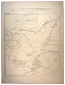
- notes: Sailing chart of the gulf, embracing Nova Scotia, Newfoundland and New Britain, complete with rhumb lines, soundings, shoals and numerous notations. The coastlines are presented in great detail, naming a profusion of harbors and ports.
- download: pdf file
This photo is copyright protected